
Coast to Coast
In 2014, spurred on by my 2013 adventure, I crossed the continental US by rail. From the east-coast (Atlantic) city of Boston I took the AMTRAK to the west-coast (Pacific) city of San Francisco.
Boston (MA)
The city of Boston was founded in 1630 by settlers fleeing persecution in England because of their Puritan beliefs. Puritans were English Protestants who felt that the English reformation did not go far enough and sought further, unwelcome, reform.
The first inhabitant of the area on which Boston now stands was an English settler named William Blaxton. Blaxton initially arrived in Weymouth in 1623 but in 1625 he moved north to what was then called the Shawmut Peninsula. In 1630 he invited the Puritans under the leadership of Isaac Johnson to settle on the peninsula and later that year Johnson renamed the settlement after his Lincolnshire (England) hometown of Boston.
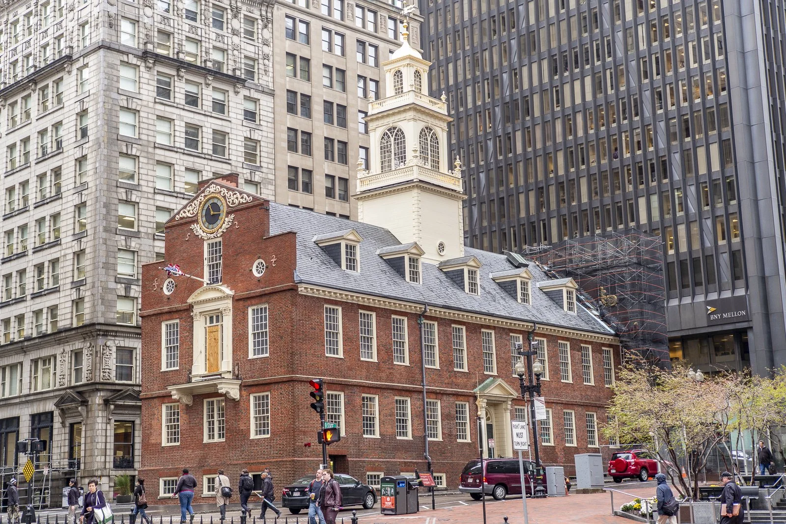
Old State House / Boston (MA) - USA
The new township formed part of the wider Province of Massachusetts Bay Colony – one of several English Colonies at the time. Fast-forward to 1765 and several had become thirteen that were, by and large, left alone to self-govern. This autonomy was brought into question when the British began to try and enforce tax legislation throughout the colonies. Many considered this unconstitutional – not for the tax per se, but because they had no voice concerning the legislation that affected them. The result was what became the American Revolution that ended with American War of Independence and the signing of the Treaty of Paris on 3rd September 1783.
Boston, and its people, played a key role in achieving independence from the British. It is consequently considered as the birthplace of the American Revolution. One significant event that took place there was what became known as the Boston Massacre – where, on 5th March 1770, British soldiers opened fire on civilians protesting over the killing of Christopher Seider eleven days earlier by a (British) customs officer. Five civilians were killed and six were wounded. Seider is considered as the first American killed in the American Revolution. Probably the most famous of Bostonian action is what came to be known as the Boston Tea Party. On 16th December 1773 a group of colonials, disguised as Native Americans, boarded the Dartmouth – a British ship carrying East India Company tea – and threw 342 tea chests into Boston Harbour. Dressed as Native Americans both disguised the colonists but was also a statement that they saw themselves as being American not English. The goal of the colonists was to protest the British tax on tea. The British saw it an act of treason.
Boston – San Francisco
The Amtrak journey from Boston to San Francisco was a four-day affair. Amtrak, for various reasons, names its intercity and long-distance routes. My first leg was the 22-hour / 1,637 km journey from Boston to Chicago on the Lake Shore Limited – presumably named because it runs along the southern shore of Lake Erie. I left Boston via its South Station. The station, built in 1899, was designed to combine four different railroads that had separate, unconnected, terminuses in the Boston area. The clock housed atop the building is ironically, given its colonial past, styled after the clocktower of the Palace of Westminster – the seat of the British Parliament.
I had a short stop-over at Chicago Union Station before catching the California Zephyr to San Francisco. It is the 4th-busiest rail station in the United States with around 140,000 passengers passing through it each day. The station opened in 1925 and one of the first to recognise the growing importance of the automobile with its entrances having places for cars to pull up curb side. Occupying an entire block its main feature is the Great Hall – a stupendously enormous room (2,200m2) and its large barrel-vaulted skylight 34m above the floor.
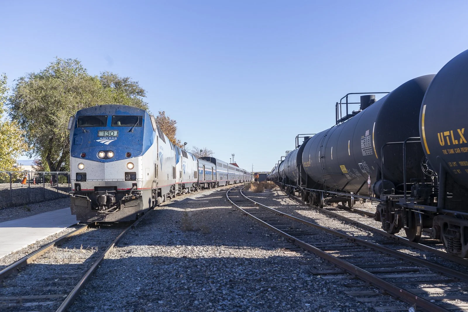
The California Zephyr / Grand Junction (CO) - USA
Entrance to the 'old' station building. The name Grand Junction is because the city lies at the confluence of the Grand (now Colorado) and Gunnison rivers - not because it was the junction of several rail lines.
From Chicago the route takes you 3,924 km west in just short of 53-hours. It travels through the Illinois prairies and across a fledgeling Mississippi River in Iowa. In Colorado, after leaving Denver in early morning, it climbs the Rocky Mountains to reach its highest altitude of 2,816 m at the Muffet Tunnel where it crosses the Great Continental Divide before following the Colorado River towards Salt Lake City. From the Utah capitol it follows the southern shore of the Great Salt Lake into Nevada and onwards to California. The California Zephyr doesn’t terminate in San Francisco itself but rather in the town of Emeryville located on the opposite side of San Francisco Bay. From Emeryville Amtrak run Thruway buses to San Francisco.
Although not the longest single-train journey on the Amtrak network the California Zephyr is the longest daily scheduled service. On this leg I had a roomette that provides two seats during the day and transformed into upper and lower beds for the night by the carriage attendant. Roomettes measure 1.07 m by 1.98 m but nevertheless felt surprisingly spacious and comfortable. Meals were taken in the dining car where a full dining service was provided by virtue of taking a cabin. Each meal had two sittings that were evenly divided between passengers and while you did not get to choose your dining partners, I found mine to be friendly.
By the time the train arrived in Emeryville it felt quite deserted compared to number of passengers I met during the journey. The viewing lounge – a bespoke carriage that allows for panoramic views – was always busy, until we left Sacramento when I found just one solo traveller. From the Amtrak terminus I, and a few others, transferred onto the Thruway bus. The journey took about thirty-minutes and crossed the southern part of San Francisco Bay across the San Francisco–Oakland Bay Bridge.
San Francisco
Like Boston, the city of San Francisco (SF) lies on a peninsular – at the tip of San Francisco Peninsula. The first European settlers where the Spanish who founded the Mission San Francisco de Asís (1776) and the military fortification Castillo de San Joaquín (1794) within what became the Province of Las Californias. The Spanish ceded the area to Mexico in 1821 and in 1848 it became part of a US territory until it was accepted into the Union on 9th September 1850 as the 31st state.
One of the first noticeable structures you see, when crossing the Bay Bridge, is the iconic 75-metre-tall clock tower that stands atop the imposing San Francisco Ferry Building – a three-storey 200 m long / 14 m wide structure. It was built in 1898 to serve as a hub for the various ferry services serving the bay community. Until the opening of the Golden Gate and Bay Bridge bridges it was the second busiest transit hub in the world. Although the building still serves as a ferry terminal the ground floor is now a marketplace with food sellers / restaurants and retail shops. The 2nd and 3rd floors provide office space.
The most iconic landmark in San Franisco is without doubt the Golden Gate Bridge that spans its namesake – a one-mile-wide strait that connects San Francisco Bay and the Pacific Ocean. The structure itself is a 2.74 km long / 227 m heigh, part suspension (1.27 km), bridge that connects the city of San Francisco with Marin County to the north. It is notable for its orange colour and art deco design. Prior to its opening in 1937 the only practical way to get from one side to the other was by ferry. The opening of the bridge, that provided a quicker and more convenient way to cross the strait, led to a drastic decline in ferry usage and in 1938 the automobile ferries stopped running. Today it facilitates the daily crossing of over 88,000 vehicles.
The San Francisco cable car network is the last manually operated system of its kind in the world and a city icon. The first line started operations in 1873. Only one of the twenty-three cable car lines established between 1873 and 1890 remain – the California Street line – that runs along California Street to/from its California St & Van Ness Ave terminus to its California St & Davis St terminus. The cars are pulled along the road by a cable that runs just below the street. The operator connects the car to the cable via a grip. When closed the grip exerts 30,000 lbs of pressure per square inch around the cable – enough to pull the street car above – that moves at just over 15km per hour. To stop, the car operator releases the grip and, along with the conductor, applies brakes to the wheels. The pressure on the grip and brakes means that they need to be replaced every few days.
Another famous landmark is Alcatraz Island that lies just over 2 km off the coast of San Francisco. The name derives from the Spanish word Alcatraces given to the island in 1775 by the Spanish explorer Juan Manuel de Ayala. On the island sits the now closed maximum-security federal prison of Alcatraz. Before becoming a federal prison in 1933 it was a military prison – having originally been built in the early 1850s for the defence of San Francisco Bay but quickly started to be used to house military prisoners. During its time as a federal prison Alcatraz held some of the most infamous American criminals including Al Capone and Robert Franklin Stroud (aka the Birdman of Alcatraz). In 1963 the prison closed because of its high operating costs. In 1972 it became part of the US National Park Service and was opened to the public in 1973.

Golden Gate Bridge / San Francisco (CA) - USA